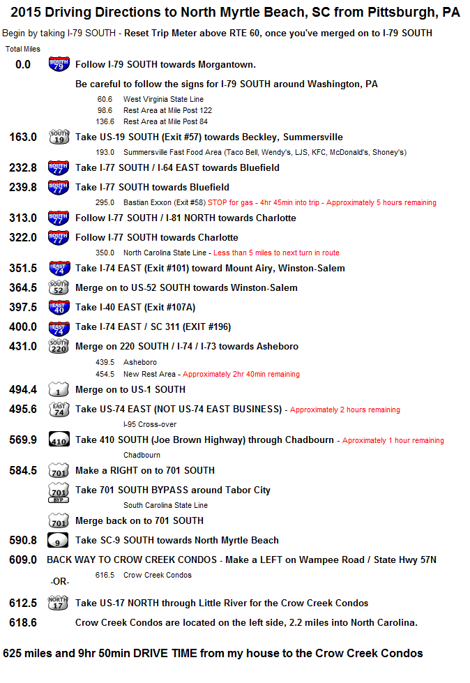
| Driving Directions to North Myrtle Beach from Pittsburgh, PA Although there are numerous ways to drive to N. Myrtle Beach, I would recommend the following route. It usually takes me 10.5 hours or less from my house to our Condos. The mileage in parentheses listed throughout these directions are equal the total miles from Exit #60-Crafton on I-79. That is where I like to reset the trip counter. Begin by driving SOUTH on I-79. Deep into West Virginia, about 2.5 hours (160 total miles), take Exit #57-Beckley to 19 SOUTH towards Beckley & Summersville. Be careful once you reach Summersville. The Summersville police are like the Kilbuck police over on Route 65, they are notorious for setting speed traps and tagging out of towners. Follow 19 SOUTH for 68 miles (228 total miles) to I-77 SOUTH towards Bluefield. I-77 SOUTH will take you all the way into North Carolina. However, you’ll probably need gas before you get there. If you can make it to the Exxon that is located on I-77 in Virginia (4 hrs 45 min or 292 total miles, Exit #58 Bastian), you won’t need gas again until you’re in Myrtle Beach. After you get gas, be careful around Wytheville, Virginia (310 total miles). I-77 SOUTH will run concurrent with I-81 NORTH for 9 miles. Be sure to follow the signs for I-77 SOUTH to Charlotte. It should take you 5 ½ hours or so to reach the North Carolina state-line. Once in North Carolina, take the exit for 74 EAST. 74 EAST will become 52 SOUTH towards Winston-Salem. NEW 2015 - Once in Winston-Salem you’ll want to take I-40 EAST - Exit #107A (397.5 miles). You'll only be on I-40 for a couple of miles. Then, take Exit #196 for I-74 EAST / SC 311 (400 miles) towards High Point. Follow I-74 EAST for about 31 miles to 220 SOUTH. You will be on 220 SOUTH (also Future I-73 & I-74) for 63 miles or so. 220 SOUTH will converge with US 1 SOUTH. About an hour past Asheboro (493 total miles), you’ll want to take the exit for 74 EAST (not Business 74 EAST, you’ll pass that first). Follow 74 EAST for 71 miles or so. 25 miles after crossing over I-95, take 410 SOUTH – Joe Brown Highway (570 total miles) through Chadbourn. Follow 410 SOUTH to 701 SOUTH. Within a mile of being on 701, keep left on the 701 bypass around Tabor City. Just after you cross the South Carolina State Line, you’ll merge back onto 701 SOUTH. Follow 701 for approximately 4 miles to 9 SOUTH Bypass just before Loris. You can Follow 9 SOUTH all the way to HIGHWAY 17 NORTH and go thru Little River on your way to the Crow Creek Condos, but I like to go the back way to Crow Creek. To go the back way, you'll want to make a left on Wampee Road / State Hwy 57. This turn is located 3.5 miles before Hwy 17, just before the junction with 31 SOUTH. Follow Wampee Road (turns into Hickman Road) for 7.5 miles to the Crow Creek Clubhouse entrance on Hickman Road. |
|